


Getting Around Paris with Ease
Paris boasts a vast and efficient public transportation system, making it easy to navigate the city and its suburbs.
The Paris Metro
With 308 metro stations spread across 16 lines, the Paris metro is the backbone of the city's public transport system. While most of the network runs underground, 26 elevated stations—notably on lines 2 and 6—offer scenic views as they traverse the city on viaducts.
Each day, the RATP network serves 12 million passengers, ranking it among the largest public transport systems in the world.
Paris Buses
In addition to the metro, Paris has a comprehensive bus network:
350 regular bus lines across Île-de-France, with around 60 lines within Paris itself
48 Noctilien night bus lines, operating between 12:30 AM and 5:30 AM
Over 5,500 bus stops in Paris and 1,000 Noctilien stops
Buses are an excellent complement to the metro and tram system, helping passengers reach areas not covered by other transport modes. The bus lines are numbered from 20 to 599, and stops are conveniently located throughout Paris and its suburbs.
Finding a Bus Stop
Looking for a bus? It's easy! Bus stops are displayed on the Bonjour app and marked in the city with signs indicating the bus number, direction, and route map. To simplify navigation, most bus stops are named after nearby landmarks, streets, or squares, often corresponding to metro station names.
The History of Parisian Buses
Did you know that the idea of a public bus system was first conceived by the famous philosopher Blaise Pascal? In 1662, he imagined carriages running on fixed routes across Paris. Later, horse-drawn omnibuses appeared in 1828, eventually giving way to motorized buses at the end of the 19th century.
Trams in Île-de-France
The Île-de-France tram network consists of 12 active lines, with two more under construction. There are 235 tram stops across the region, serving 1 million passengers daily.
The RER: Fast & Efficient Travel
Ever wondered what RER stands for? The Réseau Express Régional (Regional Express Network) was established in 1977 as the fastest way to connect Paris to its surrounding departments. The RER system includes:
5 lines (A to E)
Around 250 stations, 92 of which are managed by the RATP
Joint management of RER A and B by RATP and SNCF, while SNCF solely operates the other lines and the Transilien suburban train network
Altogether, the SNCF network serves 399 Transilien stations across Île-de-France, including 5 RER lines, 3 tram-trains, and 8 Transilien train lines.
Navigating the Paris Transport System
The entire RATP network ensures seamless connectivity:
The metro is densely concentrated within Paris and the inner suburbs
Buses serve all of Île-de-France, especially within Paris and nearby suburbs
RER lines cross Paris from one end to the other, linking different departments
Trams primarily operate on the outskirts and in suburban areas
With over 380 public transport lines, 900 km of tracks (excluding buses), and 6,000 stops and stations, the RATP network handled 2.3 billion trips in 2021.
To navigate this extensive system, download the RATP map in PDF format or visit the official RATP website for more details.
Click to enlarge the photo of the complete Paris transport map.

Metro Lines

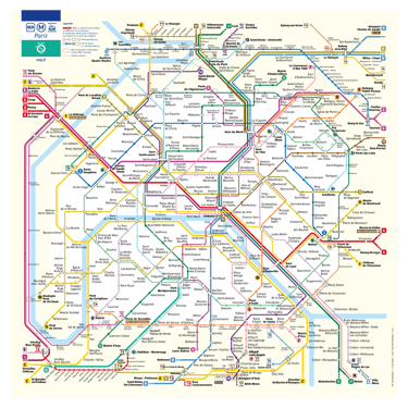


Explore the Paris Metro Map to Plan Your Journey!
Easily navigate the Paris metro network and organize your travels across the capital at a glance! Since the opening of Line 1 in 1900, the Paris metro has grown significantly. Today, the network features 16 lines, 303 stations, and 225 km of tracks. Every year, it facilitates 1.5 billion journeys, allowing both Parisians and visitors to travel efficiently across the city.
The Paris metro map provides a clear view of both underground and elevated lines, covering the entire Paris city center and its inner suburbs. Since the first metro extension beyond the city limits in 1934, many lines now cross the Périphérique, improving connections between Paris and neighboring towns.
As the city expands, so does its transport network. The Grand Paris Express project is set to transform the metro system, adding four new lines and extending Line 14, resulting in 200 km of additional tracks. By 2030, the Paris metro map will have doubled in size!
In the meantime, download the Paris metro map in PDF format for quick access and easy reference on the go!
Click on the desired line number for a detailed plan with all stops.
Click to enlarge the photo of the complete Paris transport map.

Transilien Lines


RER Lines
Click on the desired line letter to view a detailed map with all stops.
Plan Your Journey and Travel Easily in Paris and Île-de-France with the Paris RER Map
Access the Paris RER map with just one click and organize your trips effortlessly across Paris and the Île-de-France region. The Réseau Express Régional (RER), commonly known by its acronym, was introduced in the 1970s. Today, its five lines span 600 km of tracks, serving 249 stations throughout the region. The RER network accommodates 2.7 million passengers daily.
The RER system allows passengers to cross Paris quickly via underground routes and reach the suburban termini at both ends of each line. This means you can travel efficiently across the region, whether north to south, east to west, or vice versa. The Paris RER map helps you visualize the routes and stations served within Paris and its neighboring towns.
The entire Greater Paris metropolitan area is well connected by the RER network. On the Paris RER map, you'll find major destinations in both inner and outer suburbs, including:
Paris airports
Disneyland Paris
The Palace of Versailles
Massy Palaiseau train station
All of these locations are directly linked to the capital via the RER.
To navigate Paris and its suburbs more easily, download the RER map in PDF format for quick reference on the go!
The Transilien network serves Paris and the Île-de-France region, offering a reliable way to travel between the capital and its surrounding suburbs. Managed by SNCF, the Transilien trains operate on 8 lines (H, J, K, L, N, P, R, U) and cover 399 stations across the region.
The Transilien map provides a clear overview of all train routes, allowing you to plan your journey efficiently. Whether you're commuting, visiting landmarks, or traveling to business hubs, the Transilien network connects Paris to major suburban cities and key destinations, including:
La Défense business district
Versailles and its famous château
Disneyland Paris
Fontainebleau, Rambouillet, and other scenic areas
With fast and frequent service, the Transilien trains complement the Metro, RER, and tramway networks, ensuring smooth travel across the Île-de-France region.
Download the Transilien map in PDF format to have it handy for your journeys!
Click on the desired line letter to view a detailed map with all stops.


Tramway Lines
Click on the desired line letter to view a detailed map with all stops.
Your Paris Tramway Map – Accessible in One Click!
Plan your journey effortlessly with the Paris tramway map, showing all routes and stop locations across Île-de-France.
The tramway and Paris share a long history—once the main mode of public transport in the 19th century, trams disappeared from the city streets by the mid-20th century. However, since 1993, the tramway has made a strong comeback in the Parisian suburbs, now carrying over one million passengers daily.
Paris Tram Network at a Glance
12 tram lines
235 stations
126 km of tracks, mostly in the suburbs, enhancing the Greater Paris public transport system
The T3a and T3b tram lines loop around Paris, serving many Portes de Paris with direct connections to various metro and RER lines.
Express Tram-Trains: T11, T12 & T13
Unlike regular trams, T11, T12 (coming soon), and T13 are express tram-train lines that can operate on national railway tracks, providing faster suburban connections. Note: The T+ ticket is not valid on express tram lines.
Download the Paris tramway map in PDF format with just one click and navigate the network with ease!

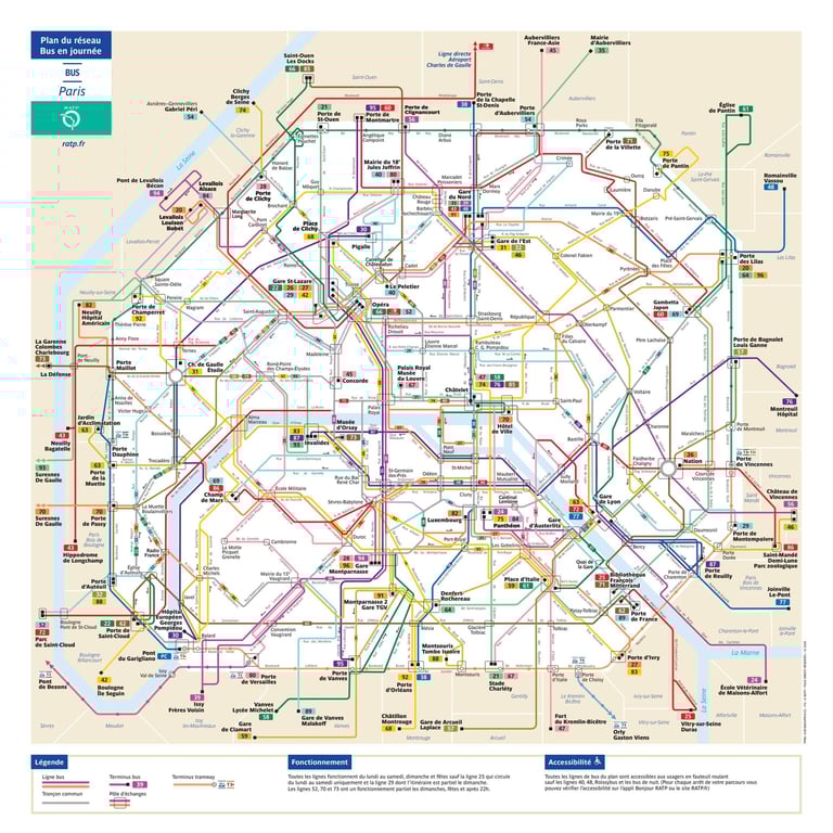
Bus Lines


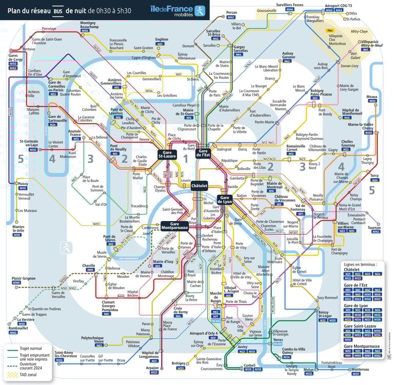
Noctilien Lines


Click to enlarge the photo of the complete Paris transport map.
Paris and Île-de-France Bus Lines Map
The bus network in Paris and Île-de-France is an essential part of the public transportation system, offering comprehensive coverage across the region. With 350 regular bus lines, including around 60 within Paris and numerous connections to metro, RER, and tramway stations, buses provide a convenient and flexible way to travel.
Key Features of the Bus Network:
Extensive coverage in Paris and the surrounding suburbs
Numbered lines from 20 to 599
Over 5,500 bus stops across Paris
Connections to all major public transport hubs
To plan your journey efficiently, download the Paris and Île-de-France bus map in PDF format and find the best route for your trip!
Click to enlarge the photo of the complete Paris transport map.
Noctilien Night Bus Lines Map in Paris and Île-de-France
The Noctilien network ensures nighttime transportation across Paris and Île-de-France, operating between 12:30 AM and 5:30 AM when metro and RER services are closed.
The Noctilien night buses include 48 lines, covering over 1,000 stops throughout the region. This network is essential for late-night travelers, whether you're heading home, catching an early flight, or commuting to work during off-peak hours.
Key Features of the Noctilien Network:
Connections to major train stations (Gare de Lyon, Gare du Nord, etc.)
Direct routes to Paris airports (CDG and Orly)
Coverage across Paris and the suburbs
Frequent service on main routes
To navigate easily, download the Noctilien network map in PDF format and plan your night trips hassle-free!

Paris Airport Transport: Lines to Reach Charles de Gaulle (CDG) and Orly Airports (ORY)
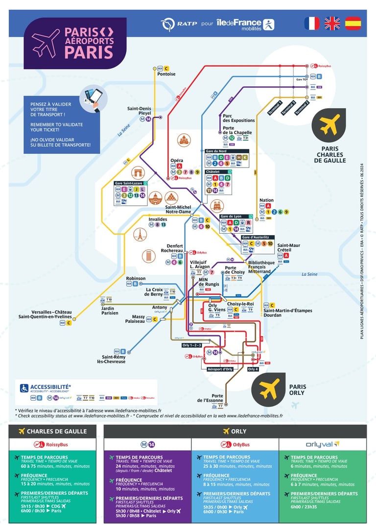

Whether you're heading to Paris-Charles de Gaulle (CDG) or Paris-Orly (ORY), several public transport options connect the city and surrounding suburbs to these major airports.
By RER (Suburban Train):
CDG Airport: Take the RER B towards Aéroport Charles de Gaulle 2 - TGV (travel time: ~35 minutes from central Paris).
Orly Airport: Take the RER B to Antony, then transfer to Orlyval, the automatic light metro (total travel time: ~35 minutes).
By Bus:
RoissyBus (CDG): Direct from Opéra (Paris center) to CDG Airport (~60 minutes).
OrlyBus (Orly): Direct from Denfert-Rochereau to Orly Airport (~30 minutes).
Noctilien Night Bus (CDG & Orly):
N140 & N143 serve CDG (from Gare de l'Est).
N31 & N131 serve Orly (from Gare de Lyon and Châtelet).
By Tramway (for Orly Airport):
Tram T7 connects Villejuif-Louis Aragon (Metro Line 7) to Orly Airport.
For detailed routes and real-time schedules, download the Paris airport transport map in PDF format or check the Paris Aiport, RATP and SNCF websites,.
Click to enlarge the photo of the complete Paris transport map.

Le Prélude
8-10 rue Ordener • 75018 PARIS
© 2025 • All rights reserved
Legal notices • Terms of Use • Privacy Policy • Cookie Management • Video Surveillance • FAQ • Site Map • Contact
Design by Jaune Cassis